About Course
Big Earth Data Analytics and Satellite Time Series for Sustainable Development Monitoring Training Course
Introduction
The Big Earth Data Analytics and Satellite Time Series for Sustainable Development Monitoring Training Course is a forward-looking program designed to empower professionals with the ability to harness vast volumes of satellite data for monitoring progress on environmental, social, and economic development goals. The course leverages cloud computing, Earth Observation (EO), and time series analysis to generate actionable insights for evidence-based policy and planning.
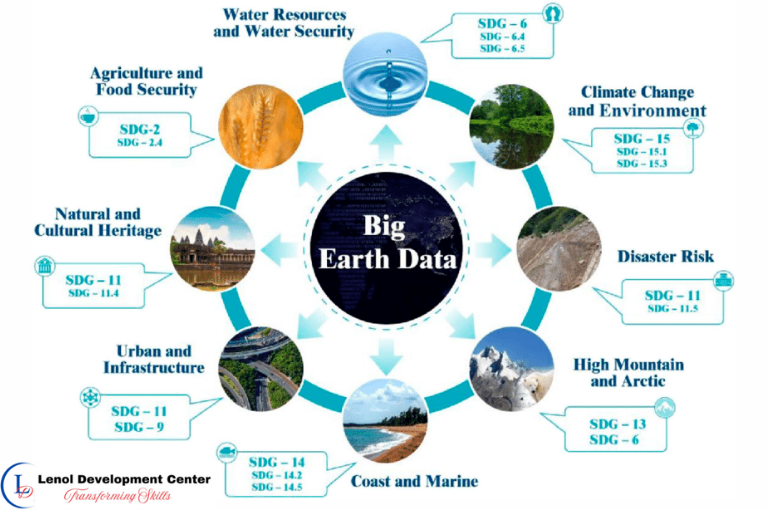
Participants will explore the power of Big Earth Data platforms such as Google Earth Engine and Copernicus DIAS, and learn to visualize long-term changes in land use, climate indicators, water resources, urban expansion, and natural ecosystems. This course is essential for those seeking to align geospatial intelligence with the Sustainable Development Goals (SDGs), climate reporting, and development frameworks.
Target Audience
- Sustainable Development Practitioners and Planners
- GIS and Remote Sensing Specialists
- Environmental and Climate Change Analysts
- Urban and Regional Development Professionals
- SDG Monitoring and Evaluation Officers
- Data Scientists and Earth Observation Engineers
- UN Agencies, NGOs, and Research Institutions
Duration
5 Days
Course Objectives
- Understand the principles of Big Earth Data and its role in SDG monitoring
- Explore cloud platforms for analyzing large-scale satellite datasets
- Perform satellite image time series analysis for trend detection
- Monitor environmental and climate indicators using EO data
- Detect land use and land cover changes over time
- Build geospatial dashboards for SDG progress visualization
- Extract and process indicators aligned to specific SDGs
- Apply spatial analytics in sustainable policy decision-making
Course Content
Course Content
Module 1: Introduction to Big Earth Data and Development Monitoring
- What is Big Earth Data and why it matters
- Key data sources: MODIS, Sentinel, Landsat, VIIRS
- Linking geospatial data to SDG frameworks
- Use cases in agriculture, water, urbanization, and health
- Challenges and ethics in Big Earth Data use
Module 2: Cloud-Based Earth Observation Platforms
- Overview of Google Earth Engine (GEE) and Sentinel Hub
- Data catalog navigation and API access
- Platform comparisons and selection criteria
- Hands-on: accessing imagery in GEE and Copernicus DIAS
- User authentication and data policy considerations
Module 3: Satellite Time Series Analysis Techniques
- Concepts in time series for Earth observation
- Image stacking, compositing, and anomaly detection
- Monitoring phenological changes and seasonal trends
- Filtering and smoothing noisy satellite data
- Change vector analysis and trajectory modeling
Module 4: Land Use, Urbanization, and Environmental Trends
- Urban sprawl and infrastructure monitoring
- Forest loss and regrowth analysis
- Agricultural expansion and land degradation
- Mapping wetlands and protected area dynamics
- Spatio-temporal classification of land use change
Module 5: Climate and Water Resources Monitoring
- NDWI and surface water extent mapping
- Drought indicators and rainfall anomaly monitoring
- Glacier retreat and snow cover trends
- Evapotranspiration and vegetation health metrics
- Cross-validation with meteorological station data
Module 6: SDG Indicator Extraction and Visualization
- Identifying geospatial proxies for SDGs (e.g. SDG 2, 6, 11, 13, 15)
- Data modeling for indicator reporting
- Customizing visualizations for decision-makers
- Creating national/subnational dashboards
- Case studies from UN and World Bank initiatives
Module 7: Building Analytical Workflows and Scripts in GEE
- JavaScript coding for satellite analysis
- Automating tasks: temporal mosaics and batch processing
- Exporting processed data and metadata
- Error handling and cloud masking techniques
- Sharing and publishing Earth Engine apps
Module 8: Capstone Project on Sustainable Development Monitoring
- Select a development theme and region of focus
- Acquire time series imagery for trend analysis
- Extract and visualize spatial indicators over time
- Design a geospatial monitoring tool or report
- Present findings and policy implications
General remarks
General remarks
- Customizable courses are available to address the specific needs of your organization.
- The participant must be conversant in English
- Participants who successfully complete this course will receive a certificate of completion from Lenol Development Center.
- The course fee for onsite training includes facilitation training materials, tea break and lunch.
- Accommodation and airport pick up are made upon request
- For any inquiries reach us through info@lenoldevelopmentcenter.com or +254 710 314 746
- Payment should be made to our bank