About Course
Advanced UAV Imagery Analysis and AI for Land Degradation and Soil Erosion Monitoring Training Course
Introduction
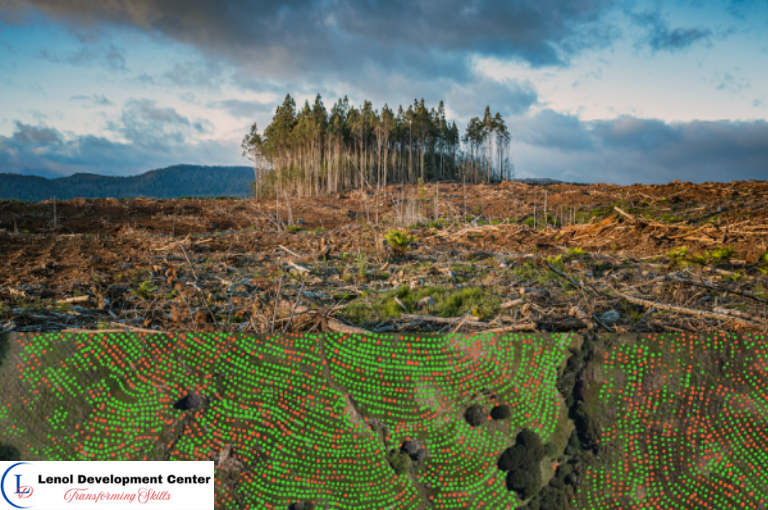
Combat environmental degradation with geospatial intelligence in the Advanced UAV Imagery Analysis and AI for Land Degradation and Soil Erosion Monitoring Training Course. As land degradation and soil erosion threaten sustainable land management, this course empowers professionals to leverage drone technology, image analytics, and AI-powered classification to detect, monitor, and mitigate degradation risks in diverse landscapes.
Participants will gain skills in UAV flight planning, high-resolution imagery processing, deep learning segmentation, erosion hotspot identification, and terrain modeling. This training equips learners with innovative tools to enhance land restoration initiatives, inform environmental policy, and drive climate-smart land use planning.
Target Audience
- Environmental and Natural Resource Managers
- UAV and Remote Sensing Specialists
- GIS Analysts and Land Surveyors
- Soil Scientists and Hydrologists
- Disaster Risk and Climate Adaptation Experts
- Academics and Researchers in Land Restoration
- Government and NGO Environmental Officers
Duration
10 Days
Course Objectives
- Understand land degradation processes and erosion indicators
- Acquire and preprocess high-resolution UAV imagery
- Apply AI algorithms for erosion feature detection and mapping
- Use photogrammetry and terrain modeling to analyze surface changes
- Integrate field data with remote sensing for erosion assessment
- Identify degradation hotspots and recommend interventions
- Build spatial dashboards for land condition monitoring
- Develop real-world geospatial solutions for erosion control
Course Content
Course Content
Module 1: Land Degradation and Erosion: Geospatial Concepts and Drivers
- Types and causes of land degradation and erosion
- Indicators of erosion in remote sensing imagery
- Land degradation neutrality and UNCCD frameworks
- Importance of scale and resolution in degradation studies
- Socio-ecological impacts of erosion
Module 2: UAV Systems and Flight Planning for Land Monitoring
- Selection of drone platforms and sensors
- Mission planning for erosion mapping
- Safety protocols and legal considerations
- Ground control points and flight calibration
- UAV data acquisition workflows
Module 3: Image Processing and Terrain Analysis from UAV Data
- Structure-from-Motion (SfM) photogrammetry
- Orthomosaic and Digital Elevation Model (DEM) creation
- Surface runoff and slope analysis
- Vegetation cover estimation and bare soil mapping
- Software tools for UAV image analysis
Module 4: AI and Deep Learning for Erosion Feature Detection
- Image segmentation using CNN and U-Net models
- Detecting rills, gullies, and sediment transport paths
- Annotating and training datasets for erosion features
- Model validation and performance tuning
- Visualization and spatial pattern analysis
Module 5: Field Data Integration and Erosion Risk Modeling
- Collecting field measurements and soil profiles
- Linking in-situ and remotely sensed data
- Building erosion susceptibility and risk maps
- Use of regression and ensemble models for prediction
- Case examples of erosion-prone landscapes
Module 6: Hotspot Identification and Restoration Planning
- Multi-criteria analysis for hotspot prioritization
- Identifying restoration corridors and buffer zones
- Mapping conservation practices (e.g., terracing, agroforestry)
- Restoration scenario simulation and impact mapping
- Engaging stakeholders through geospatial evidence
Module 7: Dashboards and Decision Support Tools for Land Management
- Building interactive dashboards using geospatial outputs
- Integration of UAV data in land use planning platforms
- Real-time alerts for soil loss detection
- Custom visualization tools for stakeholders
- Monitoring and evaluation metrics for interventions
Module 8: Capstone Project and Innovation Lab for Erosion Control
- Define a problem and select a UAV-monitored site
- Develop an erosion monitoring workflow using AI
- Produce spatial outputs and recommend mitigation actions
- Present findings to peers and evaluators
- Certification and peer-to-peer feedback
General remarks
General remarks
- Customizable courses are available to address the specific needs of your organization.
- The participant must be conversant in English
- Participants who successfully complete this course will receive a certificate of completion from Lenol Development Center.
- The course fee for onsite training includes facilitation training materials, tea break and lunch.
- Accommodation and airport pick up are made upon request
- For any inquiries reach us through info@lenoldevelopmentcenter.com or +254 710 314 746
- Payment should be made to our bank